An English teacher's blog about his travels and his digital art.

Tag: bridge

Bicycle Ride to Jang-deung Beach, Yeosu Peninsula

Spring seems to be fully here, with the cherry blossoms beginning to bloom, and azaleas, camellias and other flowers brightening the landscape. As a matter of fact, there’s an annual azalea festival at Yeongchuisan (san = mountain) this coming weekend that I’m going to visit.

So, despite 3 inches of rain last Friday, I decided to take a bicycle trip Saturday down to Jang-deung beach here on the Yeosu Peninsula. My riding companions were a couple of the new teachers, Rob, a Scotsman, and Trevor, from Canada. Now, both of these guys are much younger than I (who isn’t?) and in much better shape (insert another rhetorical question here). Trevor, especially, is quite the athlete; he’s a dedicated football (soccer) player, rides his bicycle all over the place, jogs, plays tennis and who knows what else. Rob’s no slouch either. When they suggested the ride, I was all gung-ho. Even though it looked like a fairly long trek and that it would be my first time out on my bike in almost 6 months, I thought I’d be ok. Wrong! It turned out to be a 36-mile (60 km) round trip. I haven’t ridden that far in about 20 years. Plus, it was mostly up and down hills, hills which I mostly pushed my bike up (or maybe it was pushing me). I probably spent more time pushing than riding. And, as I said, it was the first time on the bike in quite a while, so my muscles were sorely taxed by the end of the ride. I’m still recuperating.

However, it was fun for the most part and the scenery was pretty nice. We made it to the beach and stopped at a small restaurant on the way back and had some delicious fish stew. By that time, though, anything would have tasted wonderful. I just wanna thank the young studs for waiting for me at the top of all those hills. At least they didn’t have to carry me back! Here are some photos of the ride.

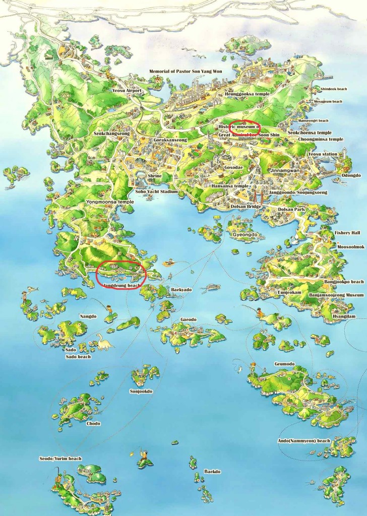
First, here’s a map of the peninsula. The university, from where we started, is circled in red at the upper right and the beach is at the left center. Click for a larger image.

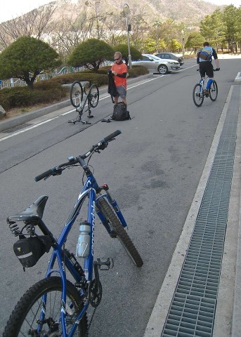
Here we’re getting prepared to start the trip from our dormitory. That’s Trevor on the left and Rob, already on his bike. My trusty steed is in the foreground.

Preparing for the bicycle trip

Beginning the bike trip

There are many small fishing towns and harbors sprinkling the coast. We all thought that it would be great to live in one of them as long as we didn’t have far to commute to and from work.

Yeosu fishing village

Fishing Village

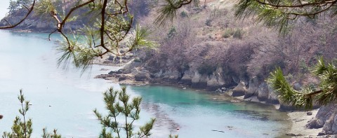
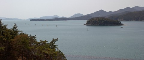
There are, of course, many beautiful spots along the coast. Here’s a small sample.

South coast of Yeosu Peninsula

South Coast View

South coast of Yeosu Peninsula

South Coast Shoreline of Yeosu Peninsula

South coast of Yeosu Peninsula

Yeosu Peninsula South Coast View

South coast of Yeosu Peninsula

Yeosu Peninsula South Coast View

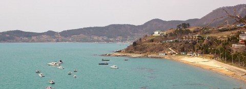
The above photo is actually the beginning of Jang-deung beach, which is out of sight at the bottom of the photo. Here’s a shot of the beach.

Jang-deung Beach

Jang-deung Beach

And, here’s a view from the end of the beach. As usual, it’s pretty hazy along the coast looking toward the sun.

Jang-deung Beach view

Another view from Jang-deung Beach

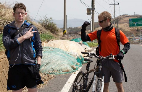
Rob and Trevor, showing no ill effects of the ride, mock my exhaustion. I took this shot just before I was put into the ambulance. 🙂

Rob and Trevor

Rob and Trevor

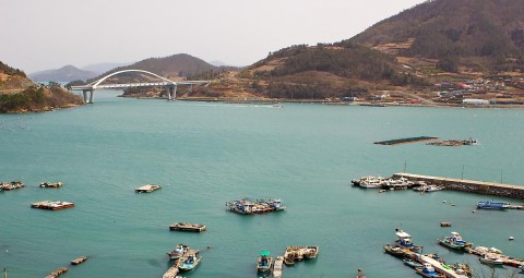
If you take a look at the map again, you can see that just to the east of Jang-deung there’s a small island called Baekyado (pronounced dough = island). Connecting the island to the mainland is this pretty little bridge. Quite a few of the islands are accessible by bridge, though many more require a ferry boat ride. Rob and Trevor are taking one of the ferries to another island this Saturday. I really wanted to go, but, like I stated earlier, I’m still recuperating and the rash I got on my, ummm, . . . well, you can guess where . . . is still bothering me, so no bike ride this weekend. The more sedate azalea festival beckons.

Baegya Island Bridge and Harbor

Baegya Island Bridge and Harbor

Our total trip time was about 7 hours, but that include dawdling on the way (the young guys waiting for the old guy to catch up) and stopping at the restaurant. I’m really looking forward to doing some other bike trips, especially later in the year when the bicycle muscles in my legs are in better shape. As always, then, more later.
Children’s Day, Turtle Ships

Before it gets to be too far past the fact, I’d better do a post on Children’s Day, which was on Thursday, May 5th. There’s really no equivalent holiday in the U.S., particularly since it’s an official national holiday, an off day for government workers (and English teachers 🙂 ). That should tell you something about how most Koreans feel about their kids. That week was also the Turtle Ship Festival, which is held in conjunction with the holiday. The festival celebrates legendary Korean naval commander Admiral Yi Sun-shin, inventor of the turtle ship. I posted last year about Children’s Day and the Turtle Ship Festival.

It was a gorgeous day–warm, with brilliant sunshine and blue skies (no yellow dust blanketing the area). The festival area is located at the Jongpo Ocean Park Walkway, from where I’ve taken a number of photos, such as this one.

Last year’s festival was a bit on the small side, but this year’s was much, much larger, due to the upcoming 2012 Expo (May-Aug 2012), so one of my former advanced level English students informed me.

Naturally, there were kids with their parents everywhere you turned, playing games, having fun, enjoying the beautiful weather.

There were dozens of tents set up for food, cultural exhibits and local organizations, with a few surprises along the way.

Here’s a fellow demonstrating kitchen knives.

This guy was doing something with these hamsters (gerbils?); I’m not sure what, but they were rather indifferent to his efforts. They lay there, not moving, either tired or drugged. If the latter, the guy should be taken to the woodshed for mistreatment of animals.

Wanna buy a sword?

Small turtle ship replicas.

Korean junk food, with french fried sweet potatoes in the lower right corner.

This food vendor was pretty good at tossing and stretching his noodle dough.

You could also buy paintings depicting the defeat of the Japanese naval forces when they tried to invade Korea way back in the late 16th century.

And continuing to walk along, I ran into surprise #1–MontanaRon is shocked to see a Montana Native American!

Ok, not really. It was a Korean dressed in Native American garb, selling flutes. Pretty cool, though.

Just a few tents down from him, I stumbled onto surprise #2–schawarmas! A couple of Turkish fellows were selling lamb or chicken schawarmas (They had a couple of Turkish flags hanging in their tent, so I assume they’re from that country.)

Unfortunately, I had just eaten and wasn’t hungry at all. They were doing a booming business. It’s coincidental that a reader left a comment on the blog about schawarmas. (Alan, are you reading this?) And, while I’m at it, let me give a BIG SHOUT OUT to his website, which features tons of recipes for this fantastic mid-Eastern food. Check it out at schwarma recipe (Unfortunately his website is no longer available). I hope the Turkish guys are here to set up a schawarma restaurant–I’ll be one of their best customers. (Yeosu has very few options if you’re hungry for something other than Korean food.)

There were also a couple of stages set up for performances, but my timing was bad–nothing much going on in that respect, though this small group was hamming it up and playing music for the crowd. Check out the older Korean on the far right and the man kicking up his heels to the left of him.

This wasn’t too far from the new bridge, which still isn’t open.

Overall, it was a great afternoon out. I can hardly wait for the Expo next year when there will be dozens of international booths (along with their respective foods). Gotta go–gettin’ hungry for breakfast and gotta work soon. More later.

Out of the Cave

We’ve been experiencing some glorious spring-like weather lately, so I decided to step out of my cave a few days ago and head on down to the Expo 2012 site to see what kind of progress is being made in preparation for next summer’s big event. The day started out overcast, but ended in some nice sunshine, so the earlier photos I took that day are a bit drab.

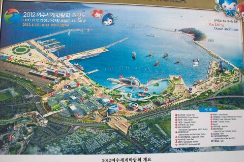
First, here’s a look at what the site is supposed to look like when it’s finished. As always, click on the images to get a larger version, especially this one in order to be able to read the map legend.

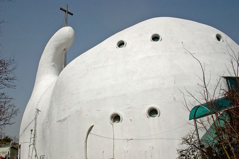
So, let’s start walking down the hill toward the site, near Odong Island. The first photo looks down on the site from just below the bizarre “whale” church. You remember the whale church, don’t you? Here’s a shot of it I took last year, in case you forgot what it looks like.

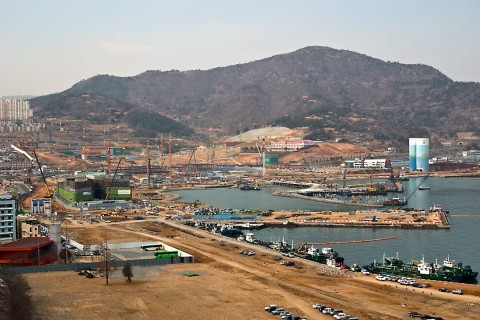
Here’s a photo of the area showing where we’re at in relation to the site.

We’re way up in the left corner, near the white structure with the thumb-like appendage sticking up. So, what does the site look like from there?

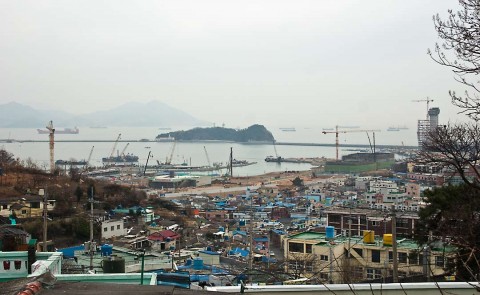
You can see Odong Island in the background with all the construction cranes working on the site. I counted a total of 18 cranes in operation, so work is proceeding apace, although only a few buildings are going up right now. The new hotel is at the far right and the green construction area just to the hotel’s left must be the aquarium, according to the map. If you enlarged the map, were standing a ways above number 9. So, let’s walk down to the site and go out to the island, just for the heck of it. We’ll climb up Jasan Park later and get some better shots of the site.

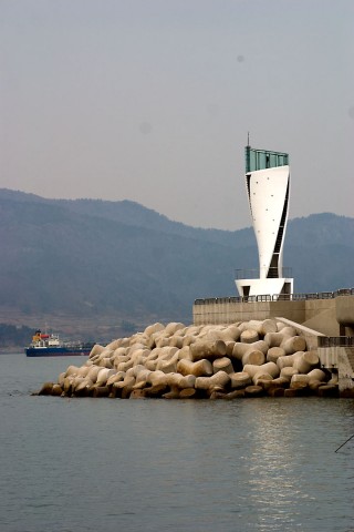
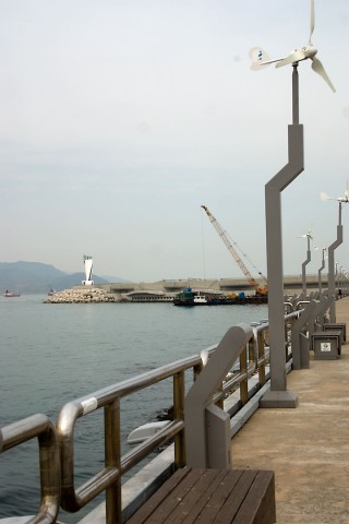
A new extension onto the jetty, with lighthouse, has been constructed, but it’s still being worked on and not yet open to the public. Here’s a couple of shots of it.

The airplane propellers at the top of the poles are wind-driven generators that provide electricity for the lighting. Here’s a closer view of the lighthouse.

Okay, let’s walk back and climb the steps to Jasan Park. On the way, from the causeway, we can see the new hotel going up (number 19 on the map).

Halfway up the steps, we get a better view of the site.

Now at the top of Jasan, here’s another view. Compare it to one taken last year, which follows the first one below.

There are a few noticeable differences–the new road snaking its way farther toward the site, a new building in the foreground, and other spot-the-difference details.

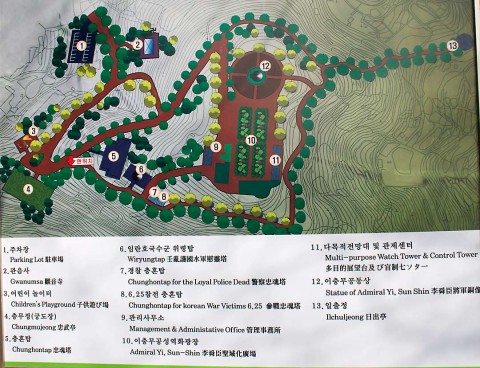
Well, now, as long as we’re here, let’s hike over to the other side of the park and see if the new bridge has been completed. Here’s a map of the park, by the way.

The previous two photos were taken from the path above number 12 on the map, the statue of the legendary Korean Admiral Yi Sun-shin.

Let’s continue along the path . . . whoa, what the heck’s that?

Ahhh, it’s one of the several monuments to Korean and international military veterans of the Korean War. This particular one, seen in silhouette against the sun, is number 5 on the map.

Alright, here’s a somewhat clear shot of the new bridge from Dolsan Island to the mainland. Hurray, it’s finished and the engineers got the two extensions to meet up in the middle! 🙂 It’s not open yet, since there’s no sign of a road going anywhere on this side.

Well, I hope you enjoyed our little walk. I’ll continue to post more photos of the ongoing construction of the Expo 2012 site, so stayed tuned for more later.
One more shot, though, to show the potential of HDR photos, about which I posted here. You can get some pretty surreal effects from HDR photography, but the photo below shows a more normal use. It’s of the hotel taken from inside the pagoda, number 13 on the Jasan Park map. If I had exposed optimally for the interior details, the background highlights would have been “blown out (overexposed);” if I had exposed for the highlights, the interior details wouldn’t have been visible (underexposed). My camera’s dynamic range could not take in both the shadow details and the background sky details in the same shot, though my eyes could easily see both. HDR (high dynamic range) to the rescue.

New Dolsan Bridge and Hamel Light

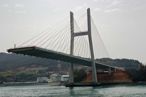
Continuing from the previous post, I walked down out of the park and toward the harbor, to the new Jongpo Ocean Park Walkway, also being built for Expo 2012. At the far end of the walkway stands one of the massive towers of the new Dolsan Bridge.

New_Dolsan_Bridge2

Here’s another shot of the other part of the bridge under construction, reaching out from Dolsan Island.

New_Dolsan_Bridge3

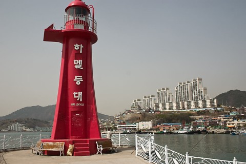
Have you ever heard of the 17th century Dutch explorer Hendrick Hamel? Neither had I. In this area is a small red lighthouse named, appropriately, Hamel Light.

Hamel_Lighthouse1

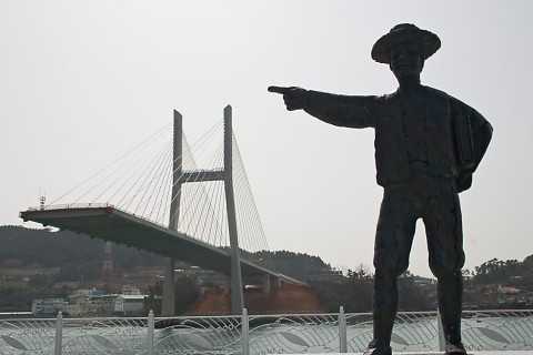
Walking a bit further, you can see this statue of Hamel.

Hamel_Statue

Engraved on a marble memorial near the statue is Hamel’s story. It reads:

Hamel and Yeosu

In January 1653, a Netherlands merchant ship, De Sperwer, set out from Texel and headed for its final destination of Nagasaki, Japan, after passing Batavia (Jakarta) in July. However, on August 16, 1653, they encountered a storm off Jeju Island and arrived on the shore of Jeju.

There were 36 survivors out of 64 crew members after the storm, and one of them was Hendrick Hamel. In May, 1654, the survivors were sent to Seoul for custody under the royal decree of the king (King HyoJong). In 1656 they were sent to the barracks of Gangjin, Jeonnam Province, and they spent seven years in captivity. Due to a food shortage caused by draught (sic), in February, 1663, 22 survivors were separately placed under custody: 12 people to Yeosu, 5 people to Suncheon, and 5 people to Namwon.

Among the 12 men sent to Yeosu, Hamel was one of the men. And they were given the duty of gate guards for Yeosu Jeolla Fortress. In early 1664, a commanding officer, Lee Do-bin, of the naval forces, was inaugurated, and he was a man of generosity. He allowed Hamel and others to live comfortably with limited freedom, and the survivors earned money by selling wool in the market to buy a ship to escape from Korea. However, in 1666, the successor of Lee, Jeong Yeong, came to command the fortress and he made it hard for the survivors to live, so the survivors decided to escape.

On September 4, 1666, they mingled with the inhabitants as every thing was going as usual. At night, they made their escape by crawling over the wall of the fortress and went to the pier. They gathered drinking water and ran toward the southern tip after passing the military vessel as the low tide started. Around the next evening, the saw the tip of Busan and finally escaped from the territory of Korea.

This is the starting place of Hamel and others for navigating toward their freedom.

An interesting story, and Hamel pops up in other sites in Korea. If you do a Google search, you can find out more about him. Here’s a close up of the light.

Hamel_Lighthouse2

Next post: Jongpo Ocean Park Walkway.

Jasan Park

To continue, somewhat belatedly, from my prior post, I was at the top of the hill where Jasan Park is situated, near Odong Island. Here’s a view of one of Yeosu’s residential areas. Notice the odd-looking structure, the white building, in the upper left.

Yeosu_From_Jasan_Park1

Here’s a cropped, zoomed-in shot.

Thumb_Church1

I’d seen this building before, but I’d never gotten close enough to find out what it’s function might be. Is it a convention center or a post-modern art gallery? We’ll find out later, because I was determined to walk to it.

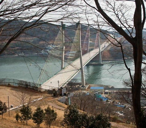
In the meantime, I walked to the other side of the park, which overlooks the construction site of the new bridge from Dolson Island to this section of Yeosu.

New_Dolsan_Bridge1

It should be an impressive addition to the Yeosu transportation system when it’s finished in time for Expo 2012.

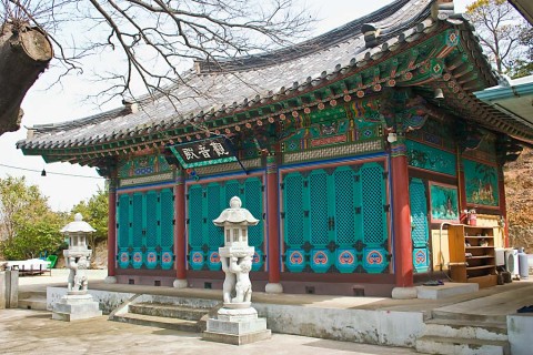
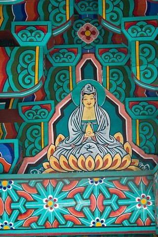
Continuing down from the bridge overlook, I stumbled across this small (one building) temple near the bottom of the hill. Below is a shot of the building and a few close-ups of some details.

Jasan_Temple1

Jasan_Temple2

Jasan_Temple3

Jasan_Temple4

If I thought that Hyangiram had a sea motif, I would probably say that this small out-of-the-way temple has a tiger guardian theme.

I’ve got a lot more to post about this walk of a few weekends past, but there’s too much to put into one entry, so I’ll spread the whole thing over several posts. Stay tuned for the New Dolsan Bridge, Hamel Light, Jongpo Ocean Park and the Mystery Building.

P.S. Weather today in Yeosu–2 inches of rain, according to the Korean Meteorological website, with just as much forecast for tomorrow.

A Few More Photos

I’ve been walking quite a bit on weekends around the city and have taken some more photos, a few of which are shown below for your perusal. The nights have become rather chilly, but daytime is still pleasantly mild. Early morning jogging requires at least half an hour before I can work up a sweat. Winter is just around the corner, but luckily, this area receives no snow, I’m told.

Here’s a photo of a church just outside of campus, nestled in the trees below a mountain. As far as I can tell, Korea’s Christian population is split between Catholics and Evangelicals, and, of course, there are the occasional Mormon missionaries bicycling around town. Hopefully, I’ll get to some of the Buddhist temples soon.

Yeosu_Church1

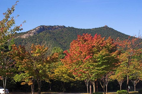
Here’s a shot of some of the fall foliage spicing up the campus. This was taken just up the hill from the dormitory where I live.

Yeosu_Mountain3

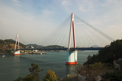
I hiked down to one of the harbors a few weekends ago and caught these scenes. The first one is of the famous Dolsan bridge, leading to the island of Dolsan. There are many nighttime photos of it, when it’s structure is highlighted by multi-colored lighting. That’s one of my assignments–getting some night shots of the area. That might have to wait until the weather gets warm again.

Dolsan_Bridge1

This is a view of the harbor looking away from the bridge.

Yeosu_Harbor4

Though there doesn’t seem to be much cargo ship traffic in this section of Yeosu, there is plenty of activity, including tour boats, ferries, fishing boats and this ship-building yard.

Boat_Building1

Nai tells me that Laos is getting hit hard by the weather systems that have {{link http://in.reuters.com/article/worldNews/idINIndia-36293520081103 inundated Vietnam}}, with heavy rains and thunderstorms dominating their weather the last several days. I doubt, however, it is enough to cause the Mekong to flood again. More later.
Thai/Laos Photos and Comments

As promised, I’m finally posting some photos and comments about my recent trip to Laos and Thailand. Some of the comments I made in earlier posts, so if I duplicate myself, forgive me. I’ll post these over a period of days (hopefully), so hang in there.

Here’s a photo of my former Andong University colleague, Tyra, with whom I rendezvoused in Bangkok. She’s a Canadian and is now basking in the sun on the beaches of Bali. We also hooked up with Eugene, another former colleague (American), but for some odd reason I didn’t get any photos of him nor did he get any of me. Strange. Perhaps we were focused in on the lovely Tyra. You can see more photos of her at the Photo Gallery. This is at Wat Pho in Bangkok, site of the Reclining Buddha.

Tyra_Buddha

So, it was up to Laos after the short stay in Bangkok. I met Nai at the train station in Nong Khai, Thailand, and we crossed the border into communist Laos. Believe me, unless you have to deal with the bureaucracy, you wouldn’t know it was a communist state. The people, for the most part, are not political. Many of them dislike the system, but they accept it with a nonchalance that reflects their easy-going lifestyle, or so it seems to me. If another system were in place, they would probably feel the same way.

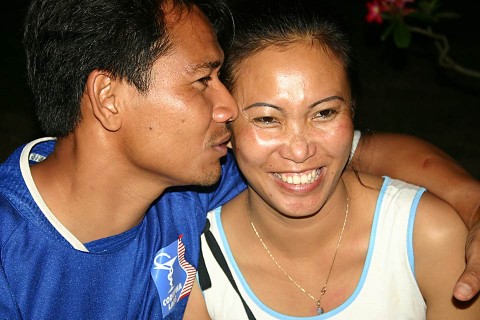
Anyway, we hung out at Nai’s house and in Vientiane for several days before heading up to Vang Vieng. Before leaving, Nai introduce me to his wonderful friends, Say (pronounced “sigh”) and his wife Joi (“joy”). Great people, who welcomed me into their home like I was a long-lost brother. I would see more of them when we returned to Vientiane later. Here are Say and Joi sharing a tender moment.

Say_Joi_small

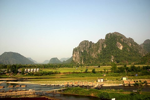
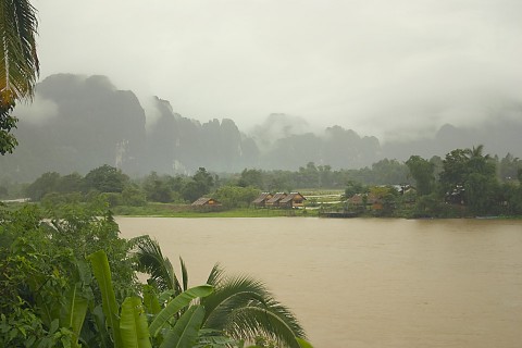
Then it was off to Vang Vieng, about which I have written. Like I stated in an earlier post, the weather was beautiful. Compare the following picture with the one I took last June.

Dry Season
Vang_Vieng_06_1
Monsoon Season
Vang_Vieng1

Here are some photos from the river float. I’m not sure I’d want to try this during the rainy part of the year when the river is high. Here are Nai, a lady whose name I forget, and Guy (the friend of the woman) putting in at the start point.

PuttingIn

Here’s Nai in a death defying slide at one of the many stops along the river.

Nai_Slide

And here is Robert, a fellow who was along with Guy and his girlfriend and who works in Vientiane, and Nai with a cool Beer Lao at one of the many beverage stations lining the river. Actually, it looks like they’ve had more than a couple.

Bev_Stop_1

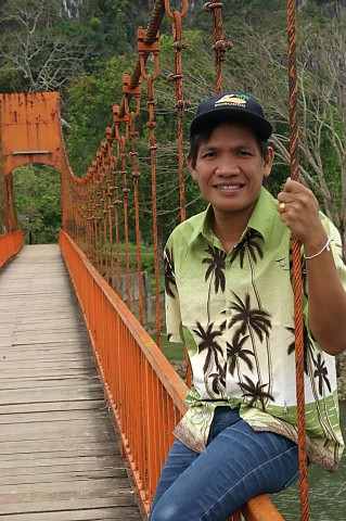
There’s not a whole lot to do in Vang Vieng besides float the river. You can explore some caves or do a little hiking in the mountains. Here, Nai sits on a quaint, little, orange suspension bridge that leads to one of the caves. (Notice the Morocco cap he’s wearing.)

Nai_on_Bridge

After a busy day on the river, though, you can visit, if that’s your thing, one of the many bars along the main tourist drag where seemingly bored tourists lay on futons watching reruns of “Friends,” something I just don’t understand. Why come all the way to Laos and then lay around like zombies entranced by the boob tube? And that seems to be all that these bars show, and there are plenty of them, at least half a dozen, all showing “Friends” reruns, speakers turned up to the max. Idiotic. Vang Vieng is infamous, though, for catering to the “pot head” tourist, so maybe the folks watching TV are actually pretty much “zoned out,” unable to do much of anything else. Just my opinion. I won’t patronize these places; the gal who came tubing with us suggested that we go to one to eat before we went out to the river, but I refused.

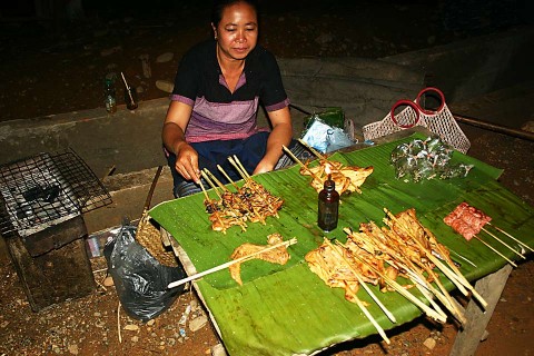
Or, you can walk along some of the side streets and try out some of the local food at one of the numerous vendors. Here we found some delicious chicken, broiled over the standard charcoal fire.

Night_Vendor

Ok, that’s enough for now. I’ll continue the journey to Luang Prabang the next post. More later.
© 2024 MontanaRon

Theme by Anders NorenUp ↑