I’m leaving Yeosu and Korea. I’ve sent out dozens of applications for jobs around the country, but it seems that Korea is so insanely paranoid about hiring older teachers that I’ve received only a couple of interview offers out of the nearly 100 applications I’ve sent, and more than one promise of a contract or interview has been broken; so much for obligations on the part of certain Korean educators. If you ever come here to teach, don’t depend on the Koreans to fulfill their obligations or promises. Even though you think their words are written in stone, everything can and just might fall apart.
I had an interview from a school in Vietnam last night, and the interviewer told me, upon hearing my gripe about the ageist Korean system, that there was no such limit in Vietnam and that older teachers were well respected there. Some countries, it seems, have more common sense than Korea. (And, by the way, I think I did pretty well on the interview, so I hope to have some posts from Vietnam in the next few months.) So be it; I’m leaving, and good riddance to me, I suppose, and to Korea from my life.
Despite the age problem, it’s been an interesting experience here in Yeosu (the city, not the university), so here is my farewell to this beautiful location on the south coast of the Republic of Korea.
Farewell to Yeosu
Yeosu, it’s time to say goodbye. I’ll be leaving you tomorrow. I’ve enjoyed my five-year sojourn in your beautiful and, by Korean standards, pocket-sized nook nestled between the mountains and the ocean, but I’ve got to move on.
I won’t forget the food, especially the raw-fish restaurants, pricey, but delicious, and the cozy little mom-and-pop diners specializing in crab, eel, squid and octopus dishes. The aroma of beef and pork grilled over glowing charcoal in small, crowded barbecue joints will linger with me wherever I go, and the spicy heat of your renowned Dolsan gat kimchi, green mustard-plant leaves smothered in deep red chili pepper sauce, will always bring sharp memories.
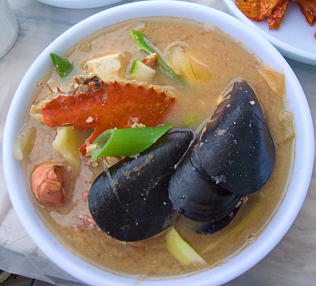
Korean Seafood Stew–Photo by Ron Anderson
I’ll miss the warm, friendly people, the ajummas and ajossies, those weather-worn old ladies and men, backs permanently hunched from doing years of stoop labor in the fields. Their occasionally dour and taciturn faces, etched by sun and wind with crevasses and fissures, are nearly always ready to return a friendly smile or a hello with one of their own. Ahn-young-hahshim-nika, “Hello,” I say, and their return smiles imply that they are surprised, but delighted, that I speak their language, even though they don’t know that that is about all I can say even after five years here.
I’ll always remember the fascinating architecture, especially the structures that house your churches. Unforgettable is the one that has an exterior shaped as a bishop’s miter and another that resembles the prow of a boat. Most remarkable, though, is one of the oddest sights in Yeosu, or in all of Korea, for that matter, the “White Whale” church, a testament to the Biblical Jonah and to the local fishing culture. It’s Moby Dick, land-locked and immortalized in concrete and plaster.

The White Whale Church-Photo by Ron Anderson
Then there was the Expo, that glorious World Exposition of 2012. Though it was only a Minor World Expo, unlike the Major Expo of Shanghai in 2010, I’ll never forget it. The excitement that accompanied it woke up your sleepy summer harbor and brought you great pride. Exotic wayfarers embraced you. Middle-Easterners in indigo and maroon turbans, Africans in yellow, green and red dress, and Latin Americans with brilliant white smiles thrilled and delighted you.
Gone for more than a year and a half are the hordes of visitors, the busy pavilions of the exhibiting countries, and the fantastic displays of light, all of it now mere scattered fragments of memory, whisps of a dream. The acres of the grounds stand empty except for small, forlorn clusters of leaves of the past autumn and black plastic bags dancing in the dark corners to the music of the winter winds whistling through the rafters.
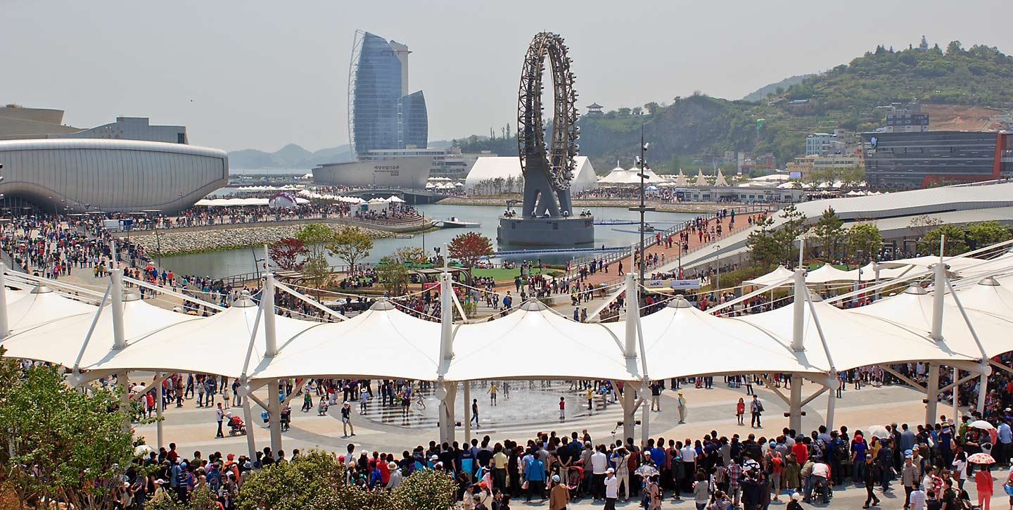
Yeosu Expo 2012-Photo by Ron Anderson
Yes, Yeosu, I’ll miss your aromas, tastes, sights and sounds. I won’t forget your friendly, welcoming inhabitants. I’ll cherish the memories wherever I go. Farewell, Yeosu. Ahnyounghi-kahsay-yo. Goodbye.
That’s my paean to Yeosu. I leave tomorrow for Bangkok, Vientiane, Haiphong, ???. Who knows? The future lies before me. Whatever it holds, I’m gonna post it here. Stay tuned, because I have a lot more coming later.


